Tight coupling of hillslopes and rivers along a tectonic gradient.
In this study, we wanted to explore hillslope-channel coupling in a landscape where we thought there was a tectonic gradient. Previous studies had shown a large variation in channel steepness along the Bolinas Ridge, North of San Francisco along the San Andreas fault. We linked the hillslopes and ridgetops to channel pixels and were able to quantify how curvature and relief along this landform evolved in concert. We believe this is the first analysis to fully couple channel steepness, hillslope relief and hillslope curvature.
Publication
Abstract
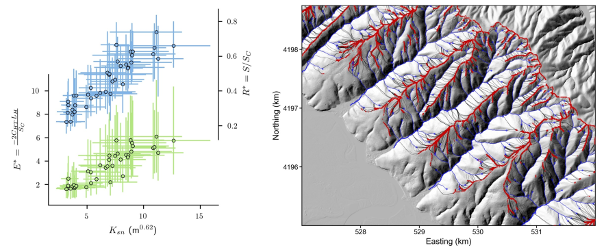
Landscape morphology reflects the spatial and temporal history of erosion. Erosion in turn embodies the competition between tectonic and climatic processes. Quantitative analysis of topography can therefore reveal the driving tectonic conditions that have influenced landscape development, when combined with theoretical understanding of erosion processes. Recent developments in the automated analysis of high-resolution (<10 m) topographic data mean that integrated analysis of hillslope and channel topographic metrics can provide understanding of the transient response of landscapes to changing boundary conditions. We perform high-resolution topographic analysis of hillslopes and channels in small (<3 km2) catchments spanning an inferred uplift gradient along the Bolinas Ridge, California, USA, revealing tight coupling between channel steepness and hillslope metrics thought to be proxies for erosion rates. We find that the concavity of channel longitudinal profiles varies inversely with uplift rates, although drainage density increases with uplift rates. Both of these results can be explained by the contribution of mass wasting processes to valley formation in steeper (high uplift rate) landscapes. At the catchment scale, hillslope and channel metrics for erosion are correlated, hillslopes and channels steepen in concert, and hilltops (ridges) get sharper with increased uplift rate. This broad agreement suggests that hillslopes are responding to erosion rates in the channel network, which implies that landscape uplift is relatively stable and prolonged. Hillslope morphology deviates systematically from the steady-state predictions of established geomorphic transport laws, suggesting that hillslope adjustment is ongoing and that relief is growing.